 Star In A Star
GPS uses Quasars to work
 GPS satellite in low Earth orbit. Credit: NASA artist’s impressionThe Global Positioning System (GPS) is precise. That precision originates in a mind-blowing place! GPS signals tell billions of people where they are each day. GPS helps pilots land planes and captains steer ships. GPS signals stamp locations onto millions of photos per minute. GPS gives you driving directions. But, where does GPS get its own GPS?
The GPS for GPS
How does GPS know where a GPS satellite is? The GPS system has to know where the GPS satellites are so it can tell the satellite. The base GPS system can’t just ask GPS, because GPS is supposed to provide the authoritative positioning data. It would set up a catch-22 situation. The answer is that, ultimately, quasars anchor the GPS system.
What is a quasar?
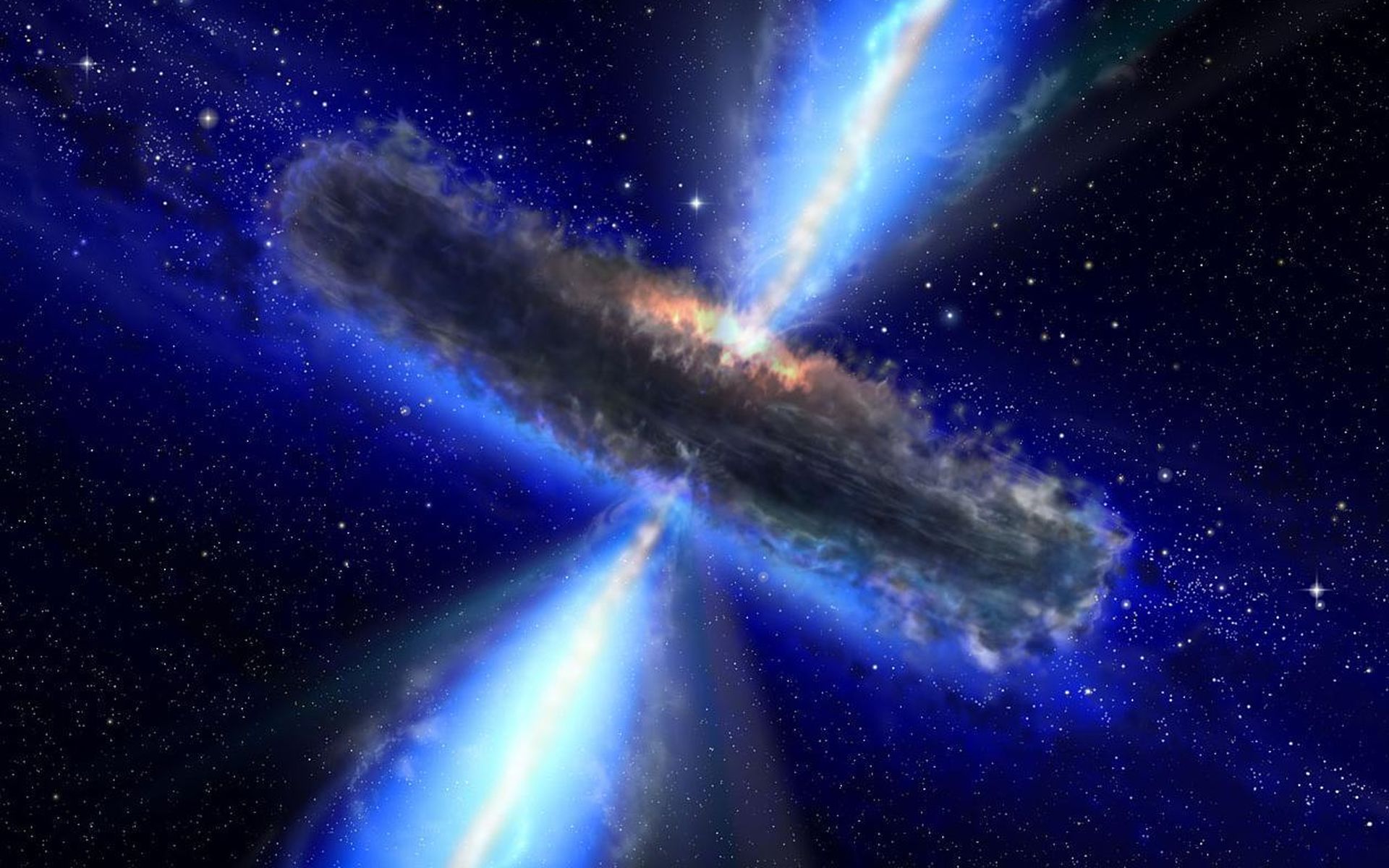 Artist’s impression of a Quasar with high energy jets. NASA image. GPS uses quasars. Yes, quasars… These are black holes that eat matter and spew jets of deadly radio energy. In more scientific terms, a quasar is a black hole in another galaxy that emits a strong radio signal. Quasars make good anchor points. The stars in our own galaxy are constantly moving. But, quasars are so far away that they stay still. Also, even though they are invisible to the human eye, they are such strong radio sources that astronomers identify and track them with radio telescopes. They use these locations to get a foundational “place” in space. GPS signals can be based on this foundational place. The location of this “zero point” is set by in the positions of 212 quasars mapped by a fleet of radio telescopes. GPS uses these quasars to set its origin. It’s the GPS for GPS.
GPS uses 212 Quasars
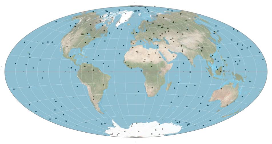 The 212 GPS Quasars. Astronomers know these as Extragalactic Radio Sources. They are the foundation for accurate GPS positioning. Quasar projection map fusion by Daniel Cummings, quasar locations courtesy NASA. A flattened version of the Quasar GPS map. The image above shows quasars plotted as Earth surface locations (as mapped on the celestial sphere). This is a map of quasars and their locations on the celestial sphere. If you want to imagine them in 3D, you can imagine straight lines or threads connected from every part of Earth. These lines poke straight out like 212 dry spaghetti strands stuck into a foam ball. Each strand points at an individual quasar.
Quasars do not move; they are far away and not visible
Imagine viewing a pencil lead edge on - it is super small. Now imagine taking it to the other end of a soccer field - even smaller, right? Now imagine that pencil lead was in San Diego and you viewed it from a location across the USA thousands of miles away in an east coast city like Washington DC. This is how precise the measurements of the quasar positions are. Astronomers who spend most of their time measuring things or building tools to measure things are called Astrometrists (astronomers who focus on the astronomical measurements). It sounds a lot like Optometrist to me. The main reason that Astrometrists chose to have GPS use quasars is because they are so far away that they do not move. In fact, all of the 212 quasars used to create the zero point are in different galaxies. The trouble with quasars is they are not visible. They have strong radio frequencies, but they are completely invisible - in fact, they are so faint, the Hubble Space telescope can’t even see them.
Do GPS satellites “talk” directly with the quasars?
GPS satellites do not talk directly to quasars. GPS satellites only “talk” to ground stations to get the time and their orbital position. Then they broadcast that data in a repeating pattern that GPS receivers can understand. But, the ground stations have to know their position. They use a “reference frame” to figure out their own position. This is the “mother of all coordinates” for astronomers. The Earth centric “reference frame” is called the Geocentric Celestial Reference System (GCRS). The GCRS looks in turn at the International Celestial Reference System (ICRS) for its position. And the ICRS looks at quasars.
The sequence of position “givers” from GPS unit to quasar.
GPS unit -> GPS Satellite -> GPS Ground Station -> GCRS -> ICRS -> Quasar Astrometrists create a “reference frame” for GPS that uses 212 quasars. The reference frame creates an origin point based on the positions of those 212 objects. All astronomy and space positioning systems use that point as zero, zero; including GPS. Everyone on Earth agrees to use this system.
Summary
Quasars are black holes in remote galaxies. Astronomers measure the positions of quasars to an astounding degree of accuracy: 40 microarcseconds. GPS uses quasars as anchor points to get the original position. Every other GPS position is based on that original position.
Fun Facts
GPS uses quasars. The official GPS time clock start date is January 6, 1980. This is kind of like GPS Birthday. We should celebrate “GPS Day” on January 6th each year!
References
- International Celestial Reference Frame (Wikipedia) — Mentions how “212 extragalactic sources (mostly quasars)” are used as a reference frame. All clocks are set based on this frame, therefore all GPS devices are “anchored” to quasars.
- NASA: ICRF2 — General audience description of GPS relationship to quasars with quotes from Chopo Ma from Goddard Space Flight Center.
- Deep Space Objects Guide Earth’s GPS System (Space.com) — Another general audience introduction with similar quotes from Chopo Ma from Goddard Space Flight Center.
- NASA Space Map Uses Quasars to Guide GPS Satnavs (The Telegraph) — A third article quoting Dr. Chopo Ma. This was big news in November 2009 but nobody has written on it much since then. Includes a nice image of the quasar “locations” as well as an artist’s impression.
- ICRF Research Paper (arXiv PDF) — More detailed paper direct from the researchers compiling and cleaning the data.
- Making the ICRF More Precise (PDF) — 2017 writings on making the ICRF even more precise.
- Astrometry Overview (University of Arizona PDF) — Astrometry overview from The University of Arizona.
- Beacons in the Sky Help Monitor Earth’s Orientation in Space (NASA) — Related article discovered after the post was written.